LARUS project coordinated by CNI successfully tests unmanned aircraft system over the Baltic Sea to support maritime search and rescue
- News
- LARUS
"At sea, the rescue itself will continue to be carried out by people in search and rescue cruisers and helicopters. However, unmanned aircraft vehicles can – If they fly automatically – create additional communication capacities and provide up-to-date situational images," says DGzRS Managing Director Capt. Udo Helge Fox, underlining the importance of this research.
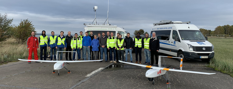
Off the Pomeranian coast between Rügen and Usedom, LARUS has for the first time integrated an unmanned aircraft system into a scenario for the Search-And-Rescue (SAR) of people in distress in the German sea areas, i.e. within the area of responsibility of the DGzRS. "The task was to track down a dummy in the Baltic Sea. The LARUS demonstrator quickly found the object, transferred the data to the search and rescue cruiser BERTHOLD BEITZ and the Maritime Rescue Co-ordination Centre (MRCC) Bremen and safely led the search and rescue vessel to the 'shipwrecked'", reports DGzRS scientist and project manager Thomas Lübcke.
Data exchange with search and rescue cruisers and the Maritime Rescue Co-ordination Centre
The LARUS system is equipped with a specially modified transponder for the Automatic Identification System (AIS) commonly used in shipping. This enables LARUS to locate AIS transmitters used in modern life jackets. The AIS signals are usually only detectable within a small radius of the person in the water. The LARUS system can detect them from the air and transmit the data to rescue units that are not yet on scene.
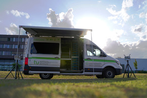
As part of the LARUS project, an unmanned fixed-wing aircraft with a wingspan of 3.6 metres, developed by the Bremen-based company Hanseatic Aviation Solutions, was further developed to meet the requirements of the maritime search and rescue service and extended by a wide range of communication and sensor components. "With the LARUS demonstrator, we have tested various optical and sensory payload components as well as novel concepts for reliable wireless networking. Throughout the entire flight all components transmit live status data to the ground, where the safe operation of the aircraft vehicle is constantly monitored. The aim is to support maritime search and rescue with powerful technology for operations under particularly difficult conditions," says the coordinator of the research association Prof. Dr.-Ing. Christian Wietfeld, head of the Chair for Communication Networks at TU Dortmund University.
New territory in many respects
With LARUS, scientists have often broken new ground. For the first time, an unmanned aircraft system with a take-off weight of about 25 kilograms was operated across the sea in German civil airspace. It simultaneously transmitted images of the situation in real time to various users, including the search and rescue cruiser BERTHOLD BEITZ of the Greifswalder Oie station and the Maritime Rescue Co-ordination Centre (MRCC) Bremen of the DGzRS.
These data can be used browser-based, i.e. without additional software, in an on-going operation scenario. The high-resolution video stream captured by the aviation system was transmitted to the ground station in real time via a novel multi-link approach developed in the project: two public LTE networks were automatically combined with a dedicated LTE network specifically set up for the LARUS system in such a way that reliable transmission was ensured even in the case of short-term gaps in the coverage of a single network. Interruptions of the wireless transmission are caused for example by interference of the direct communication path between the unmanned aircraft system and the ground stations with radio waves reflected by the surface of the sea.
In the final phase of the project, the system flew a total of around 660 nautical miles (more than 1,220 kilometers). A large part of this distance was covered at altitudes of up to 2,500 feet (around 760 metres), i.e. up to the upper limit of uncontrolled airspace, outside the visibility of the ground station.
The LARUS system was also evaluated in an experiment with a Sea King search and rescue helicopter of the German Navy for visibility testing. It took off, flew and landed up to 140 km/h fast and with wind forces up to seven Beaufort (more than 60 km/h wind speed). The German Federal Network Agency has also assigned LARUS the first German frequency for an automatic fixed wing aircraft in the SAR service. In terms of its flying skills, the system met all the expectations of the project management.
Extensive across-the-board cooperation
The test flights, which are important for aviation as well as for maritime search and rescue teams, are unique to date. They have been realised thanks to the comprehensive cooperation of authorities and organisations at both state and federal level. The state aviation authority of Mecklenburg-Western Pomerania accompanied the approval procedure at an early stage. The Federal Ministry of Transport and German Air Traffic Control (DFS) have set up two large temporary flight restriction areas for the operation of the unmanned aircraft outside visual range and at altitudes above 300 metres above ground, thus creating the legal basis for test and validation flights in front of Fischland and above the Bay of Greifswald.
Droniq, a joint venture of DFS Deutsche Flugsicherung and Deutsche Telekom, used the UTM (Unmanned Aircraft System Traffic Management System) to display the air situation. The unmanned aircraft was equipped with an LTE module with integrated SIM card and GPS receiver. The module reported the current position of the aircraft to the DFS servers via mobile radio. From there, the current air situation was made available on a web-based user interface.
LARUS will be continued until the end of the year in order to secure the results and, on this basis, to identify concrete further development requirements that should make the system suitable for practical use in the long term.
About the research project LARUS
Partners of the research project are the Communication Networks Institute (CNI) of the TU Dortmund University as network coordinator, the DGzRS as rescue coordinator, the Institute for Flight System Dynamics of the Rheinisch-Westfälische Technische Hochschule (RWTH) Aachen, as well as the companies Hanseatic Aviation Solutions GmbH, Bremen, IMST GmbH, Kamp-Lintfort, and OptoPrecision GmbH, Bremen. Associated partners were the Federal Maritime and Hydrographic Agency, the German Federal Police, Deutsche Telekom AG and Global Health Care GmbH.
The joint project, supported by the VDI Technology Centre, has been co-funded by the Federal Ministry of Education and Research (BMBF) as part of the "Innovative Rescue Systems" call in the "Research for Civil Security" security research program.
About the German Maritime Search and Rescue Service
The Deutsche Gesellschaft zur Rettung Schiffbrüchiger (DGzRS) is responsible for the maritime search and rescue service in the German areas of the North Sea and Baltic Sea. To fulfil its tasks, it keeps around 60 search and rescue cruisers and boats ready for action at 55 stations between Borkum in the west and Usedom in the east – around the clock, in all weathers. Every year, the DGzRS’ crews carry out more than 2,000 missions, coordinated by the Maritime Rescue Co-ordination Centre (MRCC) Bremen of the DGzRS. The entire independent and self-reliant work of the sea rescuers is financed exclusively by voluntary contributions, without taxpayers' money. Since the foundation of the DGzRS in 1865, its crews have rescued more than 85,000 people from distress at sea or freed them from impending dangers. The patron of the rescue teams is the Federal President of Germany.
Further Information


